 |
| They still haven't changed this since the 90s |
Saturday, December 15, 2012
Favorite Place with Google Earth
My favorite place would be Oswego, NY where I grew up on Lake Ontario and always enjoyed Britebeck Park and Harbor Fest.
The Perfect Storm
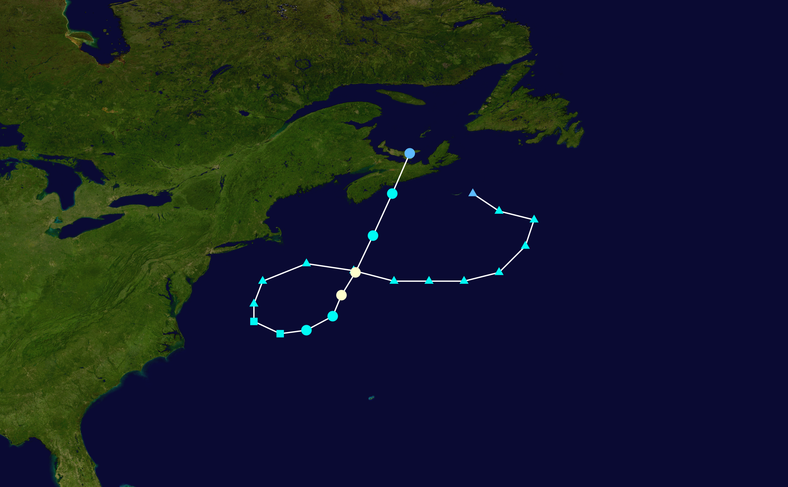
"The Perfect Storm" is the tragic story of Hurricane Grace that combine with a Nor'easter. The storm developed on October 28 and lasted until November 4th of 1991.
This storm developed from a cold front on the East Coast of the U.S. At the same time an extratropical low formed over Nova Scotia. A ridge of high pressure in Canada forced this extratropical low downward where it grew in strength in warmer waters. On October 29, 1991 Hurricane Grace arrived. The storm hit its peak over Nova Soctia on November 1 and gradually weakened.
In it's wake it left a path of destruction over Massachusetts and New Jersey. The storm left $200 million in damages and took 13 lives. Six from the fishing boat the Andrea Gale. The story of the crew was recaptured in the novel and movie The Perfefect Storm.
| Hurricane Grace |
 |
| The Perfect Storm and it's path |
Wind Rose Plots
Friday, December 14, 2012
Sun Trajectory
Sun Trajectory is the tracking of the suns position over time relative to Earth. This can be done by anyone and results will be specific based on location as well as season.
To check it out for yourself:
http://www.suncalc.net/#/32.8407,-83.6324,11/2012.12.14/22:27
This link is pretty neat and will show date specific sun patterns.
In Macon, GA on October 30th the sun rose at at 7:54AM and set at 6:46PM. By facing North we can track the location of the sun as it rises in the East and sets in the West. The position of the sun will shift visibly from right to left relative to our perspective.
Below is my diagram of Macon
Specific Time/Temp relative to Sun Trajectory:
7:53AM (Red)
Temperature: 42.1F
Humidity: 58%
8:50AM (Orange)
Temp: 44F
Humidity: 51%
11:50AM (Yellow)
Temp: 54F
Humidity: 29%
1:50PM (Green)
Temp: 60F
Humidty: 20%
4:50PM (Blue)
Temp: 59F
Humidty: 19%
5:50PM (Purple)
Temp: 57F
Humidity: 22%
6:46PM (Black)
Temp: 54F
Humidity: 25%
Hurricane Wilma
Hurricane Wilma was a storm in the Atlantic that became a category five hurricane. This hurricane at its peak reached 882mb of pressure and wind speeds of 175mph in the Caribbean Sea, and making land fall on the Yucatan Peninsula. However the storm was able to recover and make landfall in Florida as a category three storm.
This storm began as a tropical depression over the Western Caribbean in October due to a area of persistent low pressure. It was relatively weak until a burst of convection gave it enough energy to become a tropical storm. The storm formed on the 15th of October and became a category one storm on the 18th as it moved westward. Hours later the storm became a category four storm.This hurricane was so far west but still made it to Florida as a category three on the 24th of October. This storm intensified over Florida with its eye and wind speeds in tact. It began to weaken as it moved up the northeast coast. This hurricane made it's way all the way up just south of Nova Scotia on October 25th where it became a extratropical storm.
This storm is amazing, the time frame of its formation traveling from Mexico up the Yucatan Peninsula and hitting Florida. This terrorizing storm was one that did not want to leave. This storm caused 68 inches of rain in 42 hours in Cancun, Mexico alone. Havana Cuba was submerged under six feet of water, and parts of the Florida Keys were swallowed hole.
This storm began as a tropical depression over the Western Caribbean in October due to a area of persistent low pressure. It was relatively weak until a burst of convection gave it enough energy to become a tropical storm. The storm formed on the 15th of October and became a category one storm on the 18th as it moved westward. Hours later the storm became a category four storm.This hurricane was so far west but still made it to Florida as a category three on the 24th of October. This storm intensified over Florida with its eye and wind speeds in tact. It began to weaken as it moved up the northeast coast. This hurricane made it's way all the way up just south of Nova Scotia on October 25th where it became a extratropical storm.
 |
| Hurricane Wilma at its Peak |
 |
| As Wilma hit Florida |
This storm is amazing, the time frame of its formation traveling from Mexico up the Yucatan Peninsula and hitting Florida. This terrorizing storm was one that did not want to leave. This storm caused 68 inches of rain in 42 hours in Cancun, Mexico alone. Havana Cuba was submerged under six feet of water, and parts of the Florida Keys were swallowed hole.
 |
| Rainfall as it hit Mexico |
Thursday, December 13, 2012
Seasonality
As the Earth rotates around the Sun, distance relative to the Sun changes. This is in part due to the the tilt of the Earth. In the Northern Hemisphere in the winter, the sun hits the Earth at a lesser angle and shorter days are experienced. In the Southern Hemisphere it is the opposite. To better demonstrate seasonality below are five global locations.
Oslo, Norway
Sunrise: 9:14AM
Sunset: 3:08PM
High Temp: 19 F
Low Temp: 16 F
Naples, Italy
Sunrise: 7:19AM
Sunset: 4:35PM
High Temp: 55F
Low Temp: 52F
Tunis, Tunisa
Sunrise: 7:24AM
Sunset: 5:03PM
High Temp: 63 F
Low Temp: 46 F
Ndjamena, Chad
Sunrise: 6:12AM
Sunset: 5:37 PM
High Temp: 91F
Low Temp: 51F
Cape Town, South Africa
Sunrise: 5:28AM
Sunset: 7:52 PM
High Temp: 90F
Low Temp: 68F
Temperatures close to the equator have little variation but as distance grows so does variation. Sunrise and sunset times grow further apart the further apart from the equator. To the North sunrise grows later and to the South it gets earlier.
Oslo, Norway
Sunrise: 9:14AM
Sunset: 3:08PM
High Temp: 19 F
Low Temp: 16 F
Naples, Italy
Sunrise: 7:19AM
Sunset: 4:35PM
High Temp: 55F
Low Temp: 52F
Tunis, Tunisa
Sunrise: 7:24AM
Sunset: 5:03PM
High Temp: 63 F
Low Temp: 46 F
Ndjamena, Chad
Sunrise: 6:12AM
Sunset: 5:37 PM
High Temp: 91F
Low Temp: 51F
Cape Town, South Africa
Sunrise: 5:28AM
Sunset: 7:52 PM
High Temp: 90F
Low Temp: 68F
 |
| The First 3 pins represent the different locations starting at Oslo |
 |
| Chad and Cape Town a bit harder to see |
Temperatures close to the equator have little variation but as distance grows so does variation. Sunrise and sunset times grow further apart the further apart from the equator. To the North sunrise grows later and to the South it gets earlier.
How To Make a Barometer
A barometer is a instrument to measure pressure changes in the atmosphere. It is used to help forecast short term weather events.
I made a Barometer in a few simple steps:
First you will need the following:
glass jar
balloon
rubber band
pair of scissors
straw
tape
To assemble the barometer:
I made a Barometer in a few simple steps:
First you will need the following:
glass jar
balloon
rubber band
pair of scissors
straw
tape
To assemble the barometer:
- Cover the top of your jar with a balloon. You want to create an airtight seal and a smooth surface.
- Secure the balloon with a rubber band. The most important part of making the barometer is getting a good seal around the rim of the container.
- Lay the straw over the top of the wrapped container so that about two-thirds of the straw is over the opening.
- Secure the straw with a piece of tape.
- Either tape an index card to the back of the container or else set up your barometer with a sheet of notebook paper behind it.
- Record the location of the straw on your card or paper.
- Over time the straw will move up and down in response to changes in air pressure. Watch the movement of the straw and record the new readings.
Make Your Own!!!! (link to a youtube video for even more barometer fun)
The barometer I made did not seem to waiver a great deal on a daily basis but days where I noticed pressure change without the barometer I could take a measurement and see a more significant change. Over time I noticed the stress of the balloon stretching which may affect the reasonable value for daily changes. The balloon over time would need to be changed at some point in time.
Thursday, October 4, 2012
Daily Temperatures
In
Macon Georgia, the local temperature (degrees Fahrenheit) was recorded each
hour in accordance to Eastern Standard Time on October 1, 2012.
The collection of data is to demonstrate the changes in temperature over
the course of one day. The initial temperature was recorded at 8:00AM and the low at 10:00PM. The highest temperature was 80 degrees and the lowest was 72 degrees.
Tuesday, September 4, 2012
Map Maddness
Alright, so introductions are in order. This is a new blog created for my Meteorology class. This blog is a visual and chronological display of our assignments, and my personal contributions to the class.


That said, our first assignment involves identifying and explaining five types of maps. The five types of maps are choropleth maps, dot density maps, proportional symbol maps, isopelth maps, and environmental sensitivity index maps. As apart of the assignment we were also asked to find a video and upload a hyperlink to our blog of a "weather event" like a hurricane.
Choropleth Map

Above is an example of a Choropleth Map. This type of map uses shading to represent the deviation of some statistical variable in a geographic location. The map above shows the variation of water usage throughout Russia.
Dot Density Map

Above is an example of a Dot Density Map. This map uses dots to represent an amount of a statistical variable. The more variation within a geographic area means more dots. This map relies on data being scattered across a region to provide a clear image of variance across a geographic location (Australia in this instance).
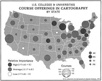
Proportional Symbol Map

The above map is an example of a proportional symbol map. This map like dot density uses dots to represent some statistical variable over a geographic location. Here each region is assigned one dot to represent the statistical variable being measured. The dot varies in size based on the variability of the data, so the larger dots have more of our variable while the smaller dots have less. This map gives less specific geographic data but provides a general comparison over a larger area.
Isopleth Map - Specific Case Topographical Map

A topographic map is a type of isopleth map. An isopleth map uses contour lines to represent variation within an area. A topographic map is a specific isopleth showing elevations rising from sea level representing different elevations of geographic locations.
Environmental Sensitivity Index Map

The map displayed above here is known as an Environmental Sensitivity Index Map or an ESI. This map conveys three types of data as opposed to one in a geographic location. These maps look much more complex then the prior maps because the data that they often portray consists of shorelines of geographic locations and the biological resources and human resources in those geographical locations.
Video Link
The link below is supposed to be a visual from satellites of Hurricane Issac.
Satellite View Issac
Video Link
The link below is supposed to be a visual from satellites of Hurricane Issac.
Satellite View Issac
Subscribe to:
Comments (Atom)


